Most first-time visitors to Zion arrive at the south entrance, collect their map at the gate, and immediately ask the same question: where do I park to drive through the canyon? The answer surprises a lot of people. From March through late November, you cannot drive Zion Canyon Scenic Drive in your own vehicle — not at all, not even briefly. The road is closed to private traffic for roughly nine months of the year. The free NPS shuttle is the only way in.
Understanding this one fact before you arrive will change how you plan your day. This guide walks you through what the Zion Canyon Scenic Drive actually is, what you will see at each stop, and how to use the shuttle without losing half the morning to a line.
What Is Zion Canyon Scenic Drive?
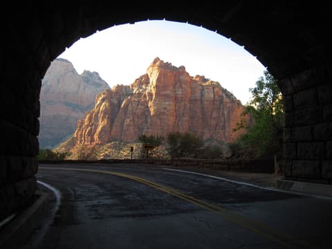
Zion Canyon Scenic Drive is the 6.2-mile paved road that runs north from Zion Canyon Junction — near the main visitor center at the south entrance — to the Temple of Sinawava at Stop 9. It follows the floor of Zion Canyon, tracing the edge of the Virgin River as the canyon walls rise on both sides. The road was built in the 1930s and is the main artery of the park for most visitors. Nearly every major trailhead in Zion Canyon sits along it.
The shuttle season runs March 7 through November 28 in 2026, with additional holiday service December 26 through January 2. During that window, private vehicles are barred from the road north of Canyon Junction. Outside that window — roughly mid-December through early March — you can drive it yourself and park at every pullout along the way.
The Shuttle: How It Works
The Zion Canyon shuttle is free. You do not need a ticket, a timed-entry reservation, or any permit beyond your park entrance pass ($35 per vehicle, valid for 7 days). The shuttle runs from 7:00 AM, with buses arriving every 5 to 10 minutes at peak hours. A full one-way trip from the Zion Canyon Visitor Center to Temple of Sinawava takes about 45 minutes; a round trip is roughly 90 minutes if you ride straight through without stopping.
The first stop is inside the park at Canyon Junction (Stop 1). Stops run north from there: Court of the Patriarchs (Stop 4), Zion Lodge (Stop 5), The Grotto (Stop 6), Weeping Rock (Stop 7), Big Bend (Stop 8), and Temple of Sinawava (Stop 9). Stops 2 and 3 are on the Springdale Town Shuttle route, not the canyon route.
One practical note: northbound shuttles fill up fast in the morning as visitors pile on at the visitor center headed for Angels Landing and the Narrows. If you want a seat rather than standing room, board by 7:30 AM or accept that the first bus or two may pass you by at peak season. The southbound return is almost always easier — stops thin out as you go, and most people are coming back at different times throughout the day.
Stop by Stop: What You Will See
Stop 1 — Canyon Junction
Canyon Junction marks where the Zion-Mt. Carmel Highway (Hwy 9) meets the scenic drive. From the bridge here you get a wide view down the Virgin River — this is one of the few spots where the canyon opens up enough to see a long stretch of the river flanked by red sandstone walls. It is a good orientation point. The canyon is still relatively wide here; the walls run about 800 feet above the valley floor. That number will more than triple by the time you reach Sinawava.
Stop 4 — Court of the Patriarchs
A short walk from the shuttle stop leads to a viewpoint facing three massive sandstone peaks: Abraham (6,890 ft), Isaac (6,831 ft), and Jacob (6,831 ft). A fourth formation, Mount Moroni, is visible to the south. These peaks are part of the Navajo Sandstone formation that dominates Zion Canyon — ancient dune fields, compressed and lifted over millions of years. The viewpoint is quick, flat, and well worth the five-minute detour off the bus.
Stop 5 — Zion Lodge
Zion Lodge is the only overnight lodging inside the park. Rooms book out months in advance; if you did not reserve early, you will not be staying here. But the cafeteria and snack bar are open to day visitors, and the grounds are a reasonable lunch stop. The Emerald Pools trailhead is also accessed from this stop — the Lower Emerald Pool is 1.2 miles round trip and suitable for most fitness levels; the Upper Pool stretches the trip to 3.0 miles with more elevation gain.
Stop 6 — The Grotto
The Grotto is a shaded picnic area with restrooms, water, and the trailhead for Angels Landing. If you have an Angels Landing permit, this is where your hike begins. The trail climbs 1,488 feet over 2.7 miles one-way, finishing with a 0.5-mile chains section along a narrow ridge to the 5,790-foot summit. The permit costs $6 per person and is issued by seasonal lottery through recreation.gov — our Getting Around section covers the permit system in more detail.
Stop 7 — Weeping Rock
Weeping Rock is one of the most geologically interesting stops on the drive, and one of the most undervisited. Water that fell as rain on the plateau above seeps down through porous Navajo Sandstone until it hits the impermeable Kayenta Formation below, then exits horizontally through the cliff face as a curtain of dripping springs. The result is a hanging garden — mosses, columbines, and maidenhair ferns clinging to an overhanging alcove. The walk from the shuttle stop is 0.4 miles round trip. Weeping Rock was also the former trailhead for the Observation Point trail; that route is currently closed due to rockfall damage.
Stop 8 — Big Bend
At Big Bend the Virgin River makes a pronounced curve north, and the canyon walls close in noticeably. The walls here reach over 2,000 feet above the road. This is a good photography stop — you can look both south toward the Court of the Patriarchs and north toward the narrowing canyon ahead. There is no major trailhead here, but the views of Angels Landing from this angle are among the best in the park.
Stop 9 — Temple of Sinawava
The last stop, 6.2 miles from Canyon Junction, is where the canyon becomes something else entirely. The walls are now 2,000 to 2,640 feet tall on both sides, only a few hundred feet apart at the road. The Virgin River fills most of the canyon floor. The Riverside Walk begins here — a 2.2-mile round-trip paved path that follows the river to the mouth of the Narrows. It is mostly flat, accessible to strollers and wheelchairs, and ends where the canyon walls meet the water and the trail becomes the river itself.
The Drive as a Geological Story
One of the things worth paying attention to as the shuttle moves north is how the canyon transforms. Near Canyon Junction, the valley is open — wide enough that you can see sky in every direction. By the time you reach Big Bend, the walls are nearly vertical and so close that afternoon light barely reaches the road. By Sinawava, you are at the bottom of a slot canyon that took the Virgin River roughly 3 million years to carve through 2,640 feet of sandstone. The road does not just connect trailheads; it traces a progression from open valley to enclosed gorge that is the canyon's defining character.
Off-Season Driving
From approximately early December through early March — outside the 2026 shuttle season — you can drive Zion Canyon Scenic Drive in your own vehicle. Every pullout is accessible. You can stop at Big Bend and spend twenty minutes photographing the walls without timing yourself to a bus. Crowds are a fraction of peak season. The trade-off is that some facilities are reduced and winter conditions can bring ice on the road early in the morning. If your schedule allows a visit between mid-November and mid-March, the self-drive option is one of the best ways to experience the canyon.
For a full breakdown of timing, parking logistics, and Springdale transit options, see our Getting Around guide. The scenic drive is, functionally, Zion Canyon — knowing how it works before you arrive is the most useful thing you can do to prepare for your visit.